|
|
Antenna Structure Registration 1219130 |
 |
Registration Info | Registration Number: 1219130 |
| File Number: A1035463 |
| FAA Study: 2006-ASW-7344-OE |
| FAA Issue Date: 11/07/2006 |
| Status: Constructed |
| Date Constructed: 01/01/2001 |
| FAA EMI: N |
| NEPA: N |
Structure Info
| Structure Type: TOWER |
| Structure Coordinates: 35-26-42.8 N 98-59-20.7 W (NAD 83) |
| Structure Coordinates: 35-26-42.6 N 98-59-19.4 W (Converted to NAD 27) |
| Structure Address: 0.75 Mi West Of Us Route 83, 3.5 Mi South Of Clinton |
| Structure City: Clinton, OK |
| Structure County: Washita County |
| Painting & Lighting Info |
FAA Circular #: 70/7460-1K |
FAA Chapters: 3, 4, 5, 12 |
Remarks: PRIOR STUDY 2006-ASW-4056-OE |
Remarks: OM&L to remain the same as prior study = PAINT/RED LIGHTS |
Remarks: PRIOR STUDY 2006-ASW-4056-OE |
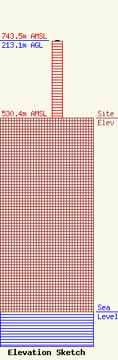
| Elevation Info |
Site Elevation: 530.4 meters (1740 ft) |
| Height of Structure: 212.1 meters (696 feet) |
| Overall Height Above Ground: 213.1 meters (699 feet) |
| Overall Height Above Mean Sea Level: 743.5 meters (2439 feet) |
| Owner Info | Wright Broadcasting Systems, Inc.
10040 Highway 54
Weatherford, OK 73096
(580) 722-5939
heston@wrightwradio.com |
| Contact Info | Wright Broadcasting Systems, Inc.
10040 Highway 54
Weatherford, OK 73096
Ray Bagby
(580) 302-1290
ray@wrightwradio.com |
