|
|
Antenna Structure Registration 1220645 |
 |
Registration Info | Registration Number: 1220645 |
| File Number: A1344572 |
| FAA Study: 2018-ANM-574-OE |
| FAA Issue Date: 06/12/2018 |
| Status: Constructed |
| Date Constructed: 06/15/2001 |
| NEPA: N |
Structure Info
| Structure Type: GTOWER |
| Structure Coordinates: 47-36-51.7 N 111-20-54.0 W (NAD 83) |
| Structure Coordinates: 47-36-51.8 N 111-20-51.1 W (Converted to NAD 27) |
| Structure Address: 668 Vineyard Road / Us-mt-5015 |
| Structure City: Great Falls, MT |
| Structure County: Cascade County |
| Painting & Lighting Info |
FAA Circular #: 70/7460-1L |
FAA Chapters: 4, 8, 12 |
Remarks: PRIOR STUDY 2000-ANM-1603-OE |
| Elevation Info |
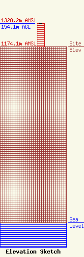
Site Elevation: 1174.1 meters (3852 ft) |
| Height of Structure: 152.8 meters (501 feet) |
| Overall Height Above Ground: 154.1 meters (506 feet) |
| Overall Height Above Mean Sea Level: 1328.2 meters (4358 feet) |
| Owner Info | Vertical Bridge CCR, LLC
22 W Atlantic Avenue
Delray Beach, FL 33444
(561) 406-4015
fcc-faa@verticalbridge.com |
| Contact Info | Vertical Bridge CCR, LLC
22 W Atlantic Avenue
Delray Beach, FL 33444
Richard Hickey
(561) 406-4015
fcc-faa@verticalbridge.com |
