|
|
Antenna Structure Registration 1223170 |
 |
Registration Info | Registration Number: 1223170 |
| File Number: A1386334 |
| FAA Study: 2026-AGL-7161-OE |
| FAA Issue Date: 05/19/2026 |
| Status: Granted |
| Date Constructed: 07/03/2001 |
| NEPA: N |
Structure Info
| Structure Type: GTOWER |
| Structure Coordinates: 40-51-52.1 N 87-35-14.1 W (NAD 83) |
| Structure Coordinates: 40-51-52.0 N 87-35-14.0 W (Converted to NAD 27) |
| Structure Address: Intersection Of County Roads 2400n And 2850e |
| Structure City: Iroquois, IL |
| Structure County: Iroquois County |
| Painting & Lighting Info |
FAA Circular #: 70/7460-1M |
FAA Chapters: 4, 8, 15 |
Remarks: PRIOR STUDY 2001-AGL-388-OE |
| Elevation Info |
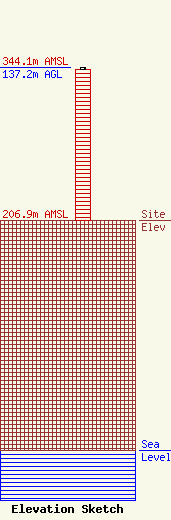
Site Elevation: 206.9 meters (679 ft) |
| Height of Structure: 135.6 meters (445 feet) |
| Overall Height Above Ground: 137.2 meters (450 feet) |
| Overall Height Above Mean Sea Level: 344.1 meters (1129 feet) |
| Owner Info | Milner Media Partners, LLC
292 N. Convent
758
BOURBONNAIS, IL 60914
(815) 933-9287
tim@milnermediapartners.com |
| Contact Info | Milner Media Partners, LLC
292 N. Convent
758
BOURBONNAIS, IL 60914
Tim Milner
(815) 933-9287
tim@milnermediapartners.com |
