|
|
Antenna Structure Registration 1224970 |
 |
Registration Info | Registration Number: 1224970 |
| File Number: A0186909 |
| FAA Study: 00-AGL-8323-OE |
| FAA Issue Date: 12/21/2000 |
| Status: Granted |
| NEPA: N |
Structure Info
| Structure Type: 4TA3 |
| Structure Coordinates: 46-23-44.9 N 94-57-49.1 W (NAD 83) |
| Structure Coordinates: 46-23-45.0 N 94-57-48.0 W (Converted to NAD 27) |
| Structure Address: Off Of Wadena County Road 104 |
| Structure City: Aldrich, MN |
| Structure County: Wadena County |
| Painting & Lighting Info |
FAA Circular #: |
FAA Chapters: NONE |
| Elevation Info |
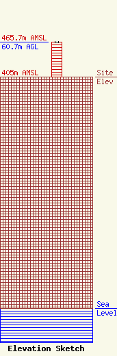
Site Elevation: 405 meters (1329 ft) |
| Height of Structure: 60.7 meters (199 feet) |
| Overall Height Above Ground: 60.7 meters (199 feet) |
| Overall Height Above Mean Sea Level: 465.7 meters (1528 feet) |
| Owner Info | D & E Enterprises
Hwy. 34 East
Box 49
Park Rapids, MN 56470
(218) 732-3306
kprmkdkk@unitelc.com |
| Contact Info | D & E Enterprises
Hwy. 34 East
Box 49
Park Rapids, MN 56470
Edward DeLaHunt
(218) 732-3306
kprmkdkk@unitelc.com |
