|
|
Antenna Structure Registration 1225227 |
 |
Registration Info | Registration Number: 1225227 |
| File Number: A1135029 |
| FAA Study: 2016-AEA-1629-OE |
| FAA Issue Date: 03/09/2016 |
| Status: Constructed |
| Date Constructed: 11/18/2001 |
| NEPA: N |
Structure Info
| Structure Type: GTOWER |
| Structure Coordinates: 38-27-9.1 N 80-27-14.6 W (NAD 83) |
| Structure Coordinates: 38-27-08.7 N 80-27-15.3 W (Converted to NAD 27) |
| Structure Address: Rice Rd. 2 Km E. Of Hwy 20, Sw Of City |
| Structure City: Webster Springs, WV |
| Structure County: Webster County |
| Painting & Lighting Info |
FAA Circular #: 70/7460-1K |
FAA Chapters: 3, 4, 5, 12 |
Remarks: PRIOR STUDY 2001-AEA-906-OE OM&L to remain the same as prior study = PAINT/RED LIGHTS |
| Elevation Info |
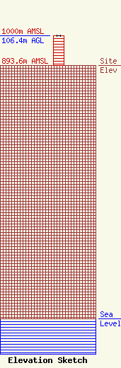
Site Elevation: 893.6 meters (2932 ft) |
| Height of Structure: 106.4 meters (349 feet) |
| Overall Height Above Ground: 106.4 meters (349 feet) |
| Overall Height Above Mean Sea Level: 1000 meters (3281 feet) |
| Owner Info | Summit Media Broadcasting, LLC
120 Main Street
Sutton, WV 26601
(304) 765-7373
al@summitmediawv.com |
| Contact Info | Summit Media Broadcasting, LLC
120 Main Street
Sutton, WV 26601
Nunzio Sergi
(304) 765-7373
al@summitmediawv.com |
