|
|
Antenna Structure Registration 1226054 |
 |
Registration Info | Registration Number: 1226054 |
| File Number: A1003475 |
| FAA Study: 2016-AEA-1410-OE |
| FAA Issue Date: 03/07/2016 |
| Status: Granted |
| Date Constructed: 04/01/1995 |
| NEPA: N |
Structure Info
| Structure Type: LTOWER |
| Structure Coordinates: 39-27-37.9 N 75-9-24.0 W (NAD 83) |
| Structure Coordinates: 39-27-37.5 N 75-09-25.3 W (Converted to NAD 27) |
| Structure Address: 637 Bridgeton Ave. |
| Structure City: Bridgeton, NJ |
| Structure County: Cumberland County |
| Painting & Lighting Info |
FAA Circular #: 70/7460-1L |
FAA Chapters: 4, 8, 12 |
Remarks: PRIOR STUDY 1994-AEA-2337-OE |
Remarks: Removed expiration date from determination. Scenario 1./jjs/case#635066 |
Remarks: PRIOR STUDY 1994-AEA-2337-OE |
Remarks: Removed expiration date from determination. Scenario 1./jjs/case#635066 |
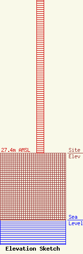
| Elevation Info |
Site Elevation: 27.4 meters (90 ft) |
| Height of Structure: 65.2 meters (214 feet) |
| Overall Height Above Ground: 66.2 meters (217 feet) |
| Overall Height Above Mean Sea Level: 93.6 meters (307 feet) |
| Owner Info | County of Cumberland
637 Bridgeton Ave.
Bridgeton, NJ 08302
(856) 455-8770
willmo@co.cumberland.nj.us |
| Contact Info | County of Cumberland
637 Bridgeton Ave
Bridgeton, NJ 08302
William Mosley
(856) 455-8526
willmo@co.cumberland.nj.us |
