|
|
Antenna Structure Registration 1226829 |
 |
Registration Info | Registration Number: 1226829 |
| File Number: A0315369 |
| FAA Study: 00-ASO-1308-OE |
| FAA Issue Date: 03/20/2000 |
| Status: Constructed |
| Date Constructed: 10/01/2000 |
| FAA EMI: N |
| NEPA: N |
Structure Info
| Structure Type: TOWER |
| Structure Coordinates: 32-30-39.0 N 85-53-32.9 W (NAD 83) |
| Structure Coordinates: 32-30-38.5 N 85-53-33.0 W (Converted to NAD 27) |
| Structure Address: 2.2 Km Ssw Of City |
| Structure City: Tallassee, AL |
| Structure County: Elmore County |
| Painting & Lighting Info |
FAA Chapters: NONE |
Remarks: Removed expiration date from determination. Scenario 1./jjs/case#635066 |
Remarks: SUPPLEMENTAL NOTICE STATES STRUCTURE REACHED GREATEST HEIGHT ON 9/24/00 |
| Elevation Info |
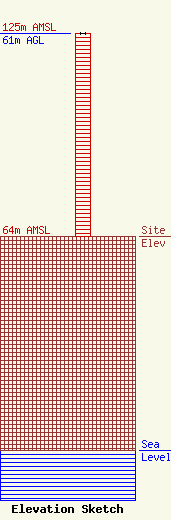
Site Elevation: 64 meters (210 ft) |
| Height of Structure: 61 meters (200 feet) |
| Overall Height Above Ground: 61 meters (200 feet) |
| Overall Height Above Mean Sea Level: 125 meters (410 feet) |
| Owner Info | MICHAEL BUTLER BROADCASTING
2045 HWY 229
780146
Tallassee, AL 36078
(334) 283-8200
mbutler@1300wtls.com |
