|
|
Antenna Structure Registration 1226999 |
 |
Registration Info | Registration Number: 1226999 |
| File Number: A0838193 |
| FAA Study: 01-ANM-3788-OE |
| FAA Issue Date: 02/13/2002 |
| Status: Constructed |
| Date Constructed: 07/12/2002 |
| FAA EMI: N |
| NEPA: N |
Structure Info
| Structure Type: TOWER |
| Structure Coordinates: 39-3-59.3 N 108-44-43.3 W (NAD 83) |
| Structure Coordinates: 39-03-59.4 N 108-44-40.9 W (Converted to NAD 27) |
| Structure Address: Black Ridge Communications Site 8.7 Miles South Of |
| Structure City: Fruita, CO |
| Structure County: Mesa County |
| Painting & Lighting Info |
FAA Circular #: 70/7460-1K |
FAA Chapters: 3, 4, 5, 12 |
Remarks: Removed expiration date from determination. Scenario 1./jjs/case#635066 |
Remarks: PRIOR STUDY 01-ANM-1244-OE |
Remarks: Removed expiration date from determination. Scenario 1./jjs/case#635066 |
Remarks: PRIOR STUDY 01-ANM-1244-OE |
| Elevation Info |
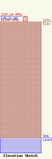
Site Elevation: 2155 meters (7070 ft) |
| Height of Structure: 104.7 meters (344 feet) |
| Overall Height Above Ground: 105.2 meters (345 feet) |
| Overall Height Above Mean Sea Level: 2260.2 meters (7415 feet) |
| Owner Info | MBC GRAND BROADCASTING INC
300 EAST ROCK ROAD
ALLENTOWN, PA 18103
(610) 797-4530
barryf@wfmz.com |
| Contact Info | MBC GRAND BROADCASTING INC
300 East Rock Road
Allentown, PA 18103
Barry Fisher
(610) 798-4080
barryf@wfmz.com |
