|
|
Antenna Structure Registration 1227467 |
 |
Registration Info | Registration Number: 1227467 |
| File Number: A0200864 |
| FAA Study: 01-ANM-1279-OE |
| FAA Issue Date: 06/07/2001 |
| Status: Granted |
| NEPA: N |
Structure Info
| Structure Type: TOWER |
| Structure Coordinates: 37-55-59.0 N 107-50-1.2 W (NAD 83) |
| Structure Coordinates: 37-55-59.0 N 107-49-59.0 W (Converted to NAD 27) |
| Structure Address: Coonskin Ridge Near Top Of Lift 7 |
| Structure City: Telluride, CO |
| Structure County: San Miguel County |
| Painting & Lighting Info |
FAA Circular #: |
FAA Chapters: NONE |
Remarks: Removed expiration date from determination. Scenario 1./jjs/case#635066 |
| Elevation Info |
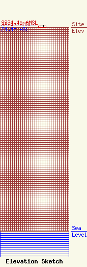
Site Elevation: 3210 meters (10531 ft) |
| Height of Structure: 24.4 meters (80 feet) |
| Overall Height Above Ground: 24.4 meters (80 feet) |
| Overall Height Above Mean Sea Level: 3234.4 meters (10612 feet) |
| Owner Info | San Miguel Educational Fund
207 N Pine St
1069
Telluride, CO 81435
(970) 728-4334
koto@infozone.org,Internet |
| Info |
