|
|
Antenna Structure Registration 1227499 |
 |
Registration Info | Registration Number: 1227499 |
| File Number: A0732238 |
| FAA Study: 01-AGL-3229-OE |
| FAA Issue Date: 06/26/2001 |
| Status: Constructed |
| Date Constructed: 09/10/2001 |
| FAA EMI: N |
| NEPA: N |
Structure Info
| Structure Type: TOWER |
| Structure Coordinates: 43-44-16.2 N 98-14-40.2 W (NAD 83) |
| Structure Coordinates: 43-44-16.3 N 98-14-38.9 W (Converted to NAD 27) |
| Structure Address: Ne Of Mt. Vernon |
| Structure City: Mt. Vernon, SD |
| Structure County: Davison County |
| Painting & Lighting Info |
FAA Circular #: 70/7460-1K |
FAA Chapters: 3, 4, 5, 12 |
Remarks: Removed expiration date from determination. Scenario 1./jjs/case#635066 |
Remarks: PRIOR STUDY 00-AGL-6631-OE |
Remarks: Removed expiration date from determination. Scenario 1./jjs/case#635066 |
| Elevation Info |
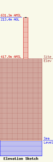
Site Elevation: 417.9 meters (1371 ft) |
| Height of Structure: 212.4 meters (697 feet) |
| Overall Height Above Ground: 213.4 meters (700 feet) |
| Overall Height Above Mean Sea Level: 631.3 meters (2071 feet) |
| Owner Info | Saga Communications of South Dakota, LLC
73 Kercheval Avenue
Grosse Pointe Farms, MI 48236
(313) 886-7070
gurbiel@sagacom.com |
| Info |
