|
|
Antenna Structure Registration 1228087 |
 |
Registration Info | Registration Number: 1228087 |
| File Number: A0300059 |
| FAA Study: 01-ASW-6518-OE |
| FAA Issue Date: 10/22/2001 |
| Status: Constructed |
| Date Constructed: 10/01/2001 |
| FAA EMI: N |
| NEPA: N |
Structure Info
| Structure Type: TOWER |
| Structure Coordinates: 32-36-51.3 N 94-52-28.4 W (NAD 83) |
| Structure Coordinates: 32-36-50.8 N 94-52-27.6 W (Converted to NAD 27) |
| Structure Address: Northeast Side Of Fm 1845, Just South Of Fm 1845 And Fm 1844 |
| Structure City: East Mountain, TX |
| Structure County: Upshur County |
| Painting & Lighting Info |
FCC Paragraph(s): A1, H, 3, 11, 21, 23 |
Remarks: OM&L TO REMAIN MED DUAL SYSTEM AS PER PRIOR STUDY |
| Elevation Info |
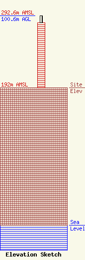
Site Elevation: 192 meters (630 ft) |
| Height of Structure: 91.4 meters (300 feet) |
| Overall Height Above Ground: 100.6 meters (330 feet) |
| Overall Height Above Mean Sea Level: 292.6 meters (960 feet) |
| Owner Info | ETEX Communications, LP
Highway 155 North
PO Box 130
Gilmer, TX 75644
(903) 797-2713
|
| Contact Info | Lukas, Nace, Gutierrez & Sachs, Chartered
1111 19th Street NW Ste 1200
Washington, DC 20036
Pamela Gist
(202) 857-3500
pgist@fcclaw.com |
