|
|
Antenna Structure Registration 1228574 |
 |
Registration Info | Registration Number: 1228574 |
| File Number: A1365843 |
| FAA Study: 2010-ANM-2206-OE |
| FAA Issue Date: 10/15/2010 |
| Status: Constructed |
| Date Constructed: 08/31/1999 |
| FAA EMI: N |
| NEPA: N |
Structure Info
| Structure Type: TOWER |
| Structure Coordinates: 45-40-33.1 N 122-22-38.9 W (NAD 83) |
| Structure Coordinates: 45-40-33.7 N 122-22-34.6 W (Converted to NAD 27) |
| Structure Address: Mt. Livingston |
| Structure City: Camas, WA |
| Structure County: Clark County |
| Painting & Lighting Info |
FAA Chapters: NONE |
Remarks: PRIOR STUDY 2009-ANM-533-OE |
| Elevation Info |
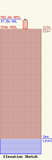
Site Elevation: 534 meters (1752 ft) |
| Height of Structure: 42.7 meters (140 feet) |
| Overall Height Above Ground: 47.8 meters (157 feet) |
| Overall Height Above Mean Sea Level: 581.8 meters (1909 feet) |
| Owner Info | Pinnacle Towers LLC
2000 Corporate Drive
Canonsburg, PA 15317
(724) 416-2400
Regulatory.Department@crowncastle.com |
| Contact Info | Crown Castle
2000 Corporate Drive
Canonsburg, PA 15317
Tom Anderson
(724) 743-6330
Tom.Anderson@crowncastle.com |
