|
|
Antenna Structure Registration 1228953 |
 |
Registration Info | Registration Number: 1228953 |
| File Number: A1279887 |
| FAA Study: 2024-ASW-1227-OE |
| FAA Issue Date: 02/20/2024 |
| Status: Granted |
| Date Constructed: 01/01/2002 |
| NEPA: N |
Structure Info
| Structure Type: B |
| Structure Coordinates: 29-31-1.6 N 98-26-11.6 W (NAD 83) |
| Structure Coordinates: 29-31-00.8 N 98-26-10.5 W (Converted to NAD 27) |
| Structure Address: 1777 N E Loop 410 |
| Structure City: San Antonio, TX |
| Structure County: Bexar County |
| Painting & Lighting Info |
FAA Circular #: 70/7460-1K |
FAA Chapters: 4, 5, 12 |
Remarks: PRIOR STUDY 2021-ASW-18023-OE |
Remarks: OM&L to remain the same as prior study = RED LIGHTS |
Remarks: PRIOR STUDY 2021-ASW-18023-OE |
Remarks: OM&L to remain the same as prior study = RED LIGHTS |
| Elevation Info |
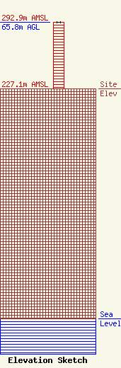
Site Elevation: 227.1 meters (745 ft) |
| Height of Structure: 65.8 meters (216 feet) |
| Overall Height Above Ground: 65.8 meters (216 feet) |
| Overall Height Above Mean Sea Level: 292.9 meters (961 feet) |
| Owner Info | KOONTZ MC COMBS 2 LTD
1777 NE LOOP 410 #928
SAN ANTONIO, TX 78217
(210) 805-9900
max.hosford@transwestern.com |
| Contact Info | KOONTZ MC COMBS 2 LTD
1777 NE Loop 410
San Antonio, TX 78217
Max Hosford
(210) 805-9900
max.hosford@transwestern.com |
