|
|
Antenna Structure Registration 1230721 |
 |
Registration Info | Registration Number: 1230721 |
| File Number: A1064437 |
| FAA Study: 2016-AEA-11380-OE |
| FAA Issue Date: 01/12/2017 |
| Status: Constructed |
| Date Constructed: 02/06/2006 |
| NEPA: N |
Structure Info
| Structure Type: 4GTA1 |
| Structure Coordinates: 40-48-48.2 N 74-27-45.8 W (NAD 83) |
| Structure Coordinates: 40-48-47.8 N 74-27-47.2 W (Converted to NAD 27) |
| Structure Address: 55 Horsehill Road |
| Structure City: Cedar Knolls, NJ |
| Structure County: Morris County |
| Painting & Lighting Info |
FAA Chapters: NONE |
Remarks: PRIOR STUDY 2002-AEA-3279-OE |
| Elevation Info |
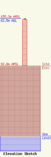
Site Elevation: 92.8 meters (304 ft) |
| Height of Structure: 61.4 meters (201 feet) |
| Overall Height Above Ground: 62.5 meters (205 feet) |
| Overall Height Above Mean Sea Level: 155.3 meters (510 feet) |
| Owner Info | The Sentinal Publishing Company.
35 Braintree Hill Office Park
Braintree, MA 02184
(781) 348-8600
msmith@greatermedia.com |
| Contact Info | Greater Media, Inc.
6501
Lawrenceville, NJ 08648
Milford Smith
(609) 895-2973
msmith@greatermedia.com |
