|
|
Antenna Structure Registration 1231145 |
 |
Registration Info | Registration Number: 1231145 |
| File Number: A1215082 |
| FAA Study: 02-ASW-2755-OE |
| Status: Dismantled |
| Date Constructed: 09/23/2002 |
| FAA EMI: N |
| NEPA: N |
Structure Info
|
| Structure Coordinates: 33-2-24.4 N 96-56-51.0 W (NAD 83) |
| Structure Coordinates: 33-02-24.0 N 96-56-50.0 W (Converted to NAD 27) |
| Structure Address: Off Of State Highway 121 |
| Structure City: Lewisville, TX |
| Structure County: Denton County |
| Painting & Lighting Info |
FAA Circular #: 70/7460-1K |
FAA Chapters: 3, 4, 5, 12 |
| Elevation Info |
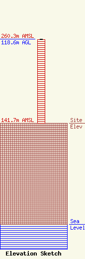
Site Elevation: 141.7 meters (465 ft) |
| Height of Structure: 117.7 meters (386 feet) |
| Overall Height Above Ground: 118.6 meters (389 feet) |
| Overall Height Above Mean Sea Level: 260.3 meters (854 feet) |
| Owner Info | Bison Media, Inc.
4880 Santa Rosa Road, Suite 300
Camarillo, CA 93012
(805) 384-4502
carlg@salem.cc |
| Contact Info | Bison Media, Inc.
4880 Santa Rosa Road, Suite 300
Camarillo, CA 93012
Carl Gluck
(805) 384-4502
carlg@salem.cc |
