|
|
Antenna Structure Registration 1231558 |
 |
Registration Info | Registration Number: 1231558 |
| File Number: A1182554 |
| FAA Study: 2016-AWP-1478-OE |
| FAA Issue Date: 03/25/2016 |
| Status: Dismantled |
| Date Constructed: 06/15/1997 |
| NEPA: N |
Structure Info
| Structure Type: LTOWER |
| Structure Coordinates: 38-34-25.9 N 121-18-13.7 W (NAD 83) |
| Structure Coordinates: 38-34-26.2 N 121-18-09.9 W (Converted to NAD 27) |
| Structure Address: 3352 Mather Field Road |
| Structure City: Rancho Cordova, CA |
| Structure County: Sacramento County |
| Painting & Lighting Info |
FAA Chapters: NONE |
Remarks: PRIOR STUDY 1996-AWP-3683-OE |
| Elevation Info |
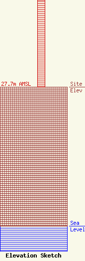
Site Elevation: 27.7 meters (91 ft) |
| Height of Structure: 18.6 meters (61 feet) |
| Overall Height Above Ground: 18.6 meters (61 feet) |
| Overall Height Above Mean Sea Level: 46.3 meters (152 feet) |
| Owner Info | ION Station Properties, LLC
601 Clearwater Park Road
West Palm Beach, FL 33401
(561) 682-4110
BiancaFrye@ionmedia.com |
| Contact Info | ION Station Properties, LLC
601 Clearwater Park Road
West Palm Beach, FL 33401
Bianca Frye
(561) 682-4110
BiancaFrye@ionmedia.com |
