|
|
Antenna Structure Registration 1233154 |
 |
Registration Info | Registration Number: 1233154 |
| File Number: A1064024 |
| FAA Study: 01-AEA-3454-OE |
| Status: Constructed |
| Date Constructed: 09/05/2003 |
| FAA EMI: N |
| NEPA: N |
Structure Info
| Structure Type: TOWER |
| Structure Coordinates: 42-56-41.8 N 76-7-6.2 W (NAD 83) |
| Structure Coordinates: 42-56-41.6 N 76-07-07.5 W (Converted to NAD 27) |
| Structure Address: 3623 Sentinel Heights Road |
| Structure City: Lafayette, NY |
| Structure County: Onondaga County |
| Painting & Lighting Info |
FAA Circular #: 70/7460-1K |
FAA Chapters: 4, 9, 12 |
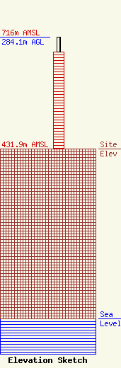
| Elevation Info |
Site Elevation: 431.9 meters (1417 ft) |
| Height of Structure: 245.3 meters (805 feet) |
| Overall Height Above Ground: 284.1 meters (932 feet) |
| Overall Height Above Mean Sea Level: 716 meters (2349 feet) |
| Owner Info | WSTQ Licensee, LLC
Pillsbury Winthrop Shaw Pittman LLP
Washington, DC 20036
(202) 663-8195
miles.mason@pillsburylaw.com |
| Contact Info | WSTQ Licensee, LLC
Pillsbury Winthrop Shaw Pittman LLP
Washington, DC 20036
(202) 663-8195
miles.mason@pillsburylaw.com |
