|
|
Antenna Structure Registration 1233572 |
 |
Registration Info | Registration Number: 1233572 |
| File Number: A1104253 |
| FAA Study: 02-AEA-0726-OE |
| FAA Issue Date: 03/13/2002 |
| Status: Constructed |
| Date Constructed: 07/11/2002 |
| FAA EMI: N |
| NEPA: N |
Structure Info
|
| Structure Coordinates: 41-7-20.2 N 78-26-28.9 W (NAD 83) |
| Structure Coordinates: 41-07-20.0 N 78-26-29.8 W (Converted to NAD 27) |
| Structure Address: 7 Miles North Of Clearfield, Pa On Mcgeorge Road, Lawrence Township |
| Structure City: Clearfield, PA |
| Structure County: Clearfield County |
| Painting & Lighting Info |
FAA Circular #: 70/7460-1K |
FAA Chapters: 4, 7, 12 |
Remarks: PRIOR STUDY 00-AEA-1146-OE |
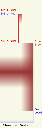
| Elevation Info |
Site Elevation: 661.3 meters (2170 ft) |
| Height of Structure: 278.1 meters (912 feet) |
| Overall Height Above Ground: 302.1 meters (991 feet) |
| Overall Height Above Mean Sea Level: 963.4 meters (3161 feet) |
| Owner Info | The Pennsylvania State University
168 Outreach Building
University Park, PA 16802-3899
(814) 865-3333
rgr11@psu.edu |
| Contact Info | The Pennsylvania State University
168 Outreach Building
University Park, PA 16802-7012
Russ Rockwell
(814) 863-5493
rgr11@psu.edu |
