|
|
Antenna Structure Registration 1233778 |
 |
Registration Info | Registration Number: 1233778 |
| File Number: A1303062 |
| FAA Study: 2016-ANM-2317-OE |
| FAA Issue Date: 09/28/2016 |
| Status: Constructed |
| Date Constructed: 05/06/2002 |
| NEPA: N |
Structure Info
| Structure Type: LTOWER |
| Structure Coordinates: 46-9-49.3 N 122-51-13.4 W (NAD 83) |
| Structure Coordinates: 46-09-49.9 N 122-51-09.0 W (Converted to NAD 27) |
| Structure Address: Mt. Brynion Road |
| Structure City: Longview, WA |
| Structure County: Cowlitz County |
| Painting & Lighting Info |
FAA Chapters: NONE |
Remarks: PRIOR STUDY 2001-ANM-3355-OE |
| Elevation Info |
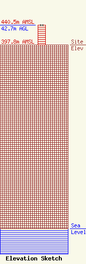
Site Elevation: 397.8 meters (1305 ft) |
| Height of Structure: 42.7 meters (140 feet) |
| Overall Height Above Ground: 42.7 meters (140 feet) |
| Overall Height Above Mean Sea Level: 440.5 meters (1445 feet) |
| Owner Info | TVT III, LLC
495 Tennessee Street, Suite #152
Memphis, TN 38103
(901) 794-9494
royal@towerventures.com |
| Contact Info | TVT III, LLC
495 Tennessee Street, Suite #152
Memphis, TN 38103
Craig Royal
(901) 794-9494
royal@towerventures.com |
