|
|
Antenna Structure Registration 1233789 |
 |
Registration Info | Registration Number: 1233789 |
| File Number: A1063850 |
| FAA Study: 02-ANM-0139-OE |
| FAA Issue Date: 04/04/2002 |
| Status: Constructed |
| Date Constructed: 10/17/2002 |
| FAA EMI: N |
| NEPA: N |
Structure Info
| Structure Type: MAST |
| Structure Coordinates: 46-58-23.6 N 123-8-16.4 W (NAD 83) |
| Structure Coordinates: 46-58-24.3 N 123-08-11.9 W (Converted to NAD 27) |
| Structure Address: Capitol Peak 19.3 Km Sw Of Olympia |
| Structure City: Mc Cleary, WA |
| Structure County: Thurston County |
| Painting & Lighting Info |
FAA Chapters: NONE |
Remarks: Removed expiration date from determination. Scenario 1./jjs/case#635066 |
| Elevation Info |
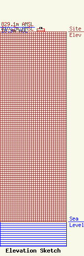
Site Elevation: 810.2 meters (2658 ft) |
| Height of Structure: 12.8 meters (42 feet) |
| Overall Height Above Ground: 18.9 meters (62 feet) |
| Overall Height Above Mean Sea Level: 829.1 meters (2720 feet) |
| Owner Info | Sinclair Seattle Licensee, LLC
Pillsbury Winthrop Shaw Pittman LLP
Washington, DC 20036
(202) 663-8195
miles.mason@pillsburylaw.com |
| Contact Info | Sinclair Seattle Licensee, LLC
Pillsbury Winthrop Shaw Pittman LLP
Washington, DC 20036
(202) 663-8195
miles.mason@pillsburylaw.com |
