|
|
Antenna Structure Registration 1234007 |
 |
Registration Info | Registration Number: 1234007 |
| File Number: A1196730 |
| FAA Study: 99-ASO-1606-OE |
| FAA Issue Date: 05/26/1999 |
| Status: Constructed |
| Date Constructed: 06/12/2002 |
| FAA EMI: N |
| NEPA: N |
Structure Info
| Structure Type: TOWER |
| Structure Coordinates: 37-35-55.0 N 85-14-47.0 W (NAD 83) |
| Structure Coordinates: 37-35-54.8 N 85-14-47.1 W (Converted to NAD 27) |
| Structure Address: 480 Radio Station Road |
| Structure City: Lebanon, KY |
| Structure County: Marion County |
| Painting & Lighting Info |
FAA Chapters: NONE |
| Elevation Info |
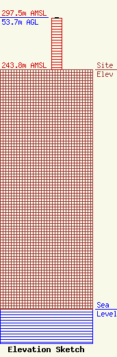
Site Elevation: 243.8 meters (800 ft) |
| Height of Structure: 52.7 meters (173 feet) |
| Overall Height Above Ground: 53.7 meters (176 feet) |
| Overall Height Above Mean Sea Level: 297.5 meters (976 feet) |
| Owner Info | Choice Radio Cental corporation
100 E. Main St.
Lebanon, KY 40033
(270) 692-3126
dave@wlskfm.com |
| Contact Info | Choice Radio Cental corporation
100 E. Main St.
Lebanon, KY 40033
Dave Colvin
(270) 692-3126
dave@wlskfm.com |
