|
|
Antenna Structure Registration 1235428 |
 |
Registration Info | Registration Number: 1235428 |
| File Number: A0278873 |
| FAA Study: 98-ACE-0534-OE |
| FAA Issue Date: 06/10/1998 |
| Status: Granted |
| NEPA: N |
Structure Info
| Structure Type: TOWER |
| Structure Coordinates: 37-3-13.1 N 100-56-27.6 W (NAD 83) |
| Structure Coordinates: 37-03-13.0 N 100-56-26.0 W (Converted to NAD 27) |
| Structure Address: 1410 N. Western Avenue |
| Structure City: Liberal, KS |
| Structure County: Seward County |
| Painting & Lighting Info |
FAA Chapters: NONE |
Remarks: Removed expiration date from determination. Scenario 1./jjs/case#635066 |
| Elevation Info |
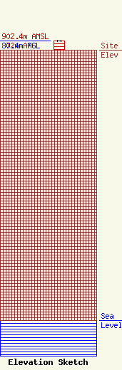
Site Elevation: 872 meters (2861 ft) |
| Height of Structure: 30.4 meters (100 feet) |
| Overall Height Above Ground: 30.4 meters (100 feet) |
| Overall Height Above Mean Sea Level: 902.4 meters (2961 feet) |
| Owner Info | Seward County Broadcasting Company, Inc.
1410 N. Western Avenue
Liberal, KS 67901
(620) 624-3891
|
| Contact Info | Wiley Rein & Fielding LLP
1776 K Street, N.W.
Washington, DC 20006
Gregory Masters
(202) 719-7000
gmasters@wrf.com |
