|
|
Antenna Structure Registration 1236377 |
 |
Registration Info | Registration Number: 1236377 |
| File Number: A1181471 |
| FAA Study: 2002-ASW-4081-OE |
| FAA Issue Date: 10/11/2002 |
| Status: Constructed |
| Date Constructed: 10/31/2003 |
| FAA EMI: N |
| NEPA: N |
Structure Info
| Structure Type: TOWER |
| Structure Coordinates: 35-26-51.3 N 94-21-54.8 W (NAD 83) |
| Structure Coordinates: 35-26-51.0 N 94-21-54.0 W (Converted to NAD 27) |
| Structure Address: Pernot Road |
| Structure City: Van Burent, AR |
| Structure County: Crawford County |
| Painting & Lighting Info |
FAA Circular #: 70/7460-1K |
FAA Chapters: 4, 8, 12 |
Remarks: Removed expiration date from determination. Scenario 1./jjs/case#635066 |
Remarks: PRIOR STUDY 2002-ASW-2422-OE |
Remarks: Removed expiration date from determination. Scenario 1./jjs/case#635066 |
| Elevation Info |
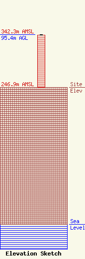
Site Elevation: 246.9 meters (810 ft) |
| Height of Structure: 94.5 meters (310 feet) |
| Overall Height Above Ground: 95.4 meters (313 feet) |
| Overall Height Above Mean Sea Level: 342.3 meters (1123 feet) |
| Owner Info | American Towers LLC
10 Presidential Way
Woburn, MA 01801
(781) 926-4500
faa-fcc@americantower.com |
| Contact Info | American Towers LLC
10 Presidential Way
Woburn, MA 01801
(781) 926-4500
faa-fcc@americantower.com |
