|
|
Antenna Structure Registration 1236919 |
 |
Registration Info | Registration Number: 1236919 |
| File Number: A1052347 |
| FAA Study: 75-GL-1452-OE2 |
| FAA Issue Date: 11/17/1975 |
| Status: Constructed |
| Date Constructed: 09/01/1977 |
| FAA EMI: N |
| NEPA: N |
Structure Info
| Structure Type: 4TA2 |
| Structure Coordinates: 45-15-25.7 N 92-22-0.1 W (NAD 83) |
| Structure Coordinates: 45-15-25.8 N 92-21-59.4 W (Converted to NAD 27) |
| Structure Address: 0.25 Miles East Of Route 46, 3 Miles South Of F Road |
| Structure City: Amery, WI |
| Structure County: Polk County |
| Painting & Lighting Info |
FAA Chapters: NONE |
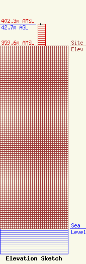
| Elevation Info |
Site Elevation: 359.6 meters (1180 ft) |
| Height of Structure: 42.7 meters (140 feet) |
| Overall Height Above Ground: 42.7 meters (140 feet) |
| Overall Height Above Mean Sea Level: 402.3 meters (1320 feet) |
| Owner Info | Zoe Communications Inc.
345 Hwy 63 South
190
Shell Lake, WI 54871
(715) 468-9500
obergmike@gmail.com |
| Contact Info | Zoe Communications Inc.
345 Hwy 63 South
190
Shell Lake, WI 54871
Mike Oberg
(715) 468-9500
obergmike@gmail.com |
