|
|
Antenna Structure Registration 1236979 |
 |
Registration Info | Registration Number: 1236979 |
| File Number: A1238365 |
| FAA Study: 2002-ACE-2112-OE |
| FAA Issue Date: 11/07/2002 |
| Status: Constructed |
| Date Constructed: 04/01/1999 |
| FAA EMI: N |
| NEPA: N |
Structure Info
| Structure Type: TOWER |
| Structure Coordinates: 40-12-45.0 N 100-38-58.0 W (NAD 83) |
| Structure Coordinates: 40-12-45.0 N 100-38-56.4 W (Converted to NAD 27) |
| Structure Address: 1811 West "o" Street |
| Structure City: Mccook, NE |
| Structure County: Red Willow County |
| Painting & Lighting Info |
FAA Chapters: NONE |
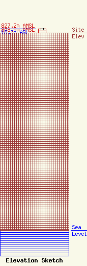
| Elevation Info |
Site Elevation: 808.9 meters (2654 ft) |
| Height of Structure: 18.3 meters (60 feet) |
| Overall Height Above Ground: 18.3 meters (60 feet) |
| Overall Height Above Mean Sea Level: 827.2 meters (2714 feet) |
| Owner Info | Armada Media Corporation
258 So Main Street
Fond du Lac, WI 54935
(920) 906-9900
cbernier@armadamedia.com |
| Contact Info | Armada Media Corporation
258 So Main Street
Fond du Lac, WI 54935
Chris Bernier
(920) 906-9900
cbernier@armadamedia.com |
