|
|
Antenna Structure Registration 1237608 |
 |
Registration Info | Registration Number: 1237608 |
| File Number: A0660376 |
| FAA Study: 2003-AWP-226-OE |
| FAA Issue Date: 01/28/2003 |
| Status: Constructed |
| Date Constructed: 11/18/2003 |
| FAA EMI: N |
| NEPA: N |
Structure Info
| Structure Type: TOWER |
| Structure Coordinates: 36-29-56.3 N 121-42-47.0 W (NAD 83) |
| Structure Coordinates: 36-29-56.4 N 121-42-43.2 W (Converted to NAD 27) |
| Structure Address: 1.5 Mi. Nne |
| Structure City: Carmel Valley, CA |
| Structure County: Monterey County |
| Painting & Lighting Info |
FAA Chapters: NONE |
| Elevation Info |
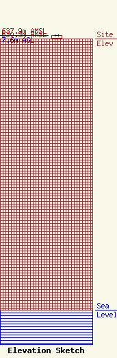
Site Elevation: 630.3 meters (2068 ft) |
| Height of Structure: 7.6 meters (25 feet) |
| Overall Height Above Ground: 7.6 meters (25 feet) |
| Overall Height Above Mean Sea Level: 637.9 meters (2093 feet) |
| Owner Info | COUNTY OF MONTEREY
1590 Moffett Street
Salinas, CA 93905
(831) 759-6919
AsstDirTelecom@co.monterey.ca.us |
| Contact Info | Monterey, County of
855 E. Laurel Dr. Bldg "D"
Salinas, CA 93905
John Parker
(831) 796-1327
parkerjl@co.monterey.ca.us |
