|
|
Antenna Structure Registration 1238916 |
 |
Registration Info | Registration Number: 1238916 |
| File Number: A0325474 |
| FAA Study: 2002-ANM-691-OE |
| FAA Issue Date: 07/12/2002 |
| Status: Granted |
| NEPA: N |
Structure Info
| Structure Type: TOWER |
| Structure Coordinates: 40-16-53.4 N 111-56-11.1 W (NAD 83) |
| Structure Coordinates: 40-16-53.6 N 111-56-08.3 W (Converted to NAD 27) |
| Structure Address: 2723 North 11500 West Atop Lake Mountain |
| Structure City: Provo, UT |
| Structure County: Utah County |
| Painting & Lighting Info |
FAA Circular #: |
FAA Chapters: NONE |
Remarks: Removed expiration date from determination. Scenario 1./jjs/case#635066 |
| Elevation Info |
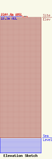
Site Elevation: 2322.5 meters (7620 ft) |
| Height of Structure: 18.3 meters (60 feet) |
| Overall Height Above Ground: 18.3 meters (60 feet) |
| Overall Height Above Mean Sea Level: 2340.8 meters (7680 feet) |
| Owner Info | Radio Communications
599 So. State Street
Orem, UT 84058
(801) 225-2779
|
