|
|
Antenna Structure Registration 1239161 |
 |
Registration Info | Registration Number: 1239161 |
| File Number: A0328264 |
| FAA Study: 00-ASO-6070-OE |
| FAA Issue Date: 09/14/2000 |
| Status: Granted |
| NEPA: N |
Structure Info
| Structure Type: B |
| Structure Coordinates: 35-6-44.1 N 89-53-31.2 W (NAD 83) |
| Structure Coordinates: 35-06-43.8 N 89-53-30.9 W (Converted to NAD 27) |
| Structure Address: 5100 Poplar Avenue |
| Structure City: Memphis, TN |
| Structure County: Shelby County |
| Painting & Lighting Info |
FAA Circular #: 70/7460-1K |
FAA Chapters: 4, 5, 12 |
Remarks: PRIOR STUDY 81-ASO-0310-OE |
| Elevation Info |
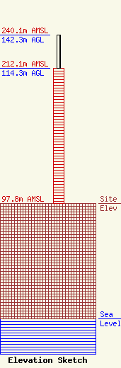
Site Elevation: 97.8 meters (321 ft) |
| Height of Structure: 114.3 meters (375 feet) |
| Overall Height Above Ground: 142.3 meters (467 feet) |
| Overall Height Above Mean Sea Level: 240.1 meters (788 feet) |
| Owner Info | TRIZECHAHN TBI CLARK TOWER LLC
5100 POPLAR AVENUE 711
MEMPHIS, TN 38137
(901) 682-9260
lisa.ritenour@trz.com |
