|
|
Antenna Structure Registration 1239247 |
 |
Registration Info | Registration Number: 1239247 |
| File Number: A1180164 |
| FAA Study: 92-ASO-2206-OE |
| FAA Issue Date: 02/03/1993 |
| Status: Constructed |
| Date Constructed: 06/26/2003 |
| FAA EMI: N |
| NEPA: N |
Structure Info
| Structure Type: TOWER |
| Structure Coordinates: 36-28-25.0 N 88-56-42.0 W (NAD 83) |
| Structure Coordinates: 36-28-24.8 N 88-56-41.8 W (Converted to NAD 27) |
| Structure Address: Tn-highway 51 And Hicks Branch, Obion County |
| Structure City: Union City, TN |
| Structure County: Obion County |
| Painting & Lighting Info |
FCC Paragraph(s): 1, 3, 4, 13, 21 |
Remarks: RED LIGHTS/PAINT |
| Elevation Info |
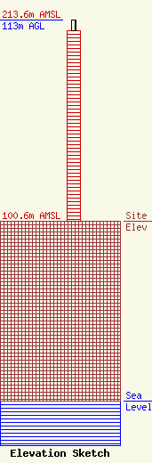
Site Elevation: 100.6 meters (330 ft) |
| Height of Structure: 107.2 meters (352 feet) |
| Overall Height Above Ground: 113 meters (371 feet) |
| Overall Height Above Mean Sea Level: 213.6 meters (701 feet) |
| Owner Info | Wood Performance, Inc. dba Wood Communications
417 West Reelfoot Avenue
Union City, TN 38261
(731) 884-4444
robin@woodcommunications.com |
| Contact Info | Wood Communications
417 Reelfoot Avenue
Union City, TN 38261
Robin Wood
(731) 884-4444
robin@woodcommunications.com |
