|
|
Antenna Structure Registration 1239752 |
 |
Registration Info | Registration Number: 1239752 |
| File Number: A0390396 |
| FAA Study: 2003-ACE-1360-OE |
| FAA Issue Date: 07/11/2003 |
| Status: Constructed |
| Date Constructed: 08/09/2004 |
| FAA EMI: N |
| NEPA: N |
Structure Info
| Structure Type: TOWER |
| Structure Coordinates: 37-14-11.1 N 97-1-32.1 W (NAD 83) |
| Structure Coordinates: 37-14-11.0 N 97-01-31.0 W (Converted to NAD 27) |
| Structure Address: 2429 Morningview Drive |
| Structure City: Winfield, KS |
| Structure County: Cowley County |
| Painting & Lighting Info |
FAA Chapters: NONE |
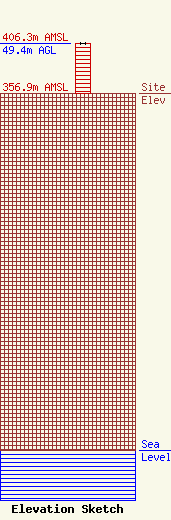
| Elevation Info |
Site Elevation: 356.9 meters (1171 ft) |
| Height of Structure: 49.4 meters (162 feet) |
| Overall Height Above Ground: 49.4 meters (162 feet) |
| Overall Height Above Mean Sea Level: 406.3 meters (1333 feet) |
| Owner Info | Johnson Enterprises, Inc.
338 South KLEY Drive
249
Wellington, KS 67152-0707
(620) 326-3341
kley@sutv.com |
