|
|
Antenna Structure Registration 1240224 |
 |
Registration Info | Registration Number: 1240224 |
| File Number: A0344123 |
| FAA Study: 2003-ACE-1189-OE |
| FAA Issue Date: 07/25/2003 |
| Status: Constructed |
| Date Constructed: 09/18/2003 |
| FAA EMI: N |
| NEPA: N |
Structure Info
| Structure Type: TOWER |
| Structure Coordinates: 38-22-18.9 N 97-39-45.1 W (NAD 83) |
| Structure Coordinates: 38-22-18.9 N 97-39-43.9 W (Converted to NAD 27) |
| Structure Address: 411 E. Euclid |
| Structure City: Mcpherson, KS |
| Structure County: McPherson County |
| Painting & Lighting Info |
FAA Chapters: NONE |
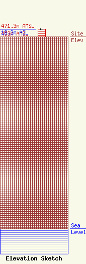
| Elevation Info |
Site Elevation: 453 meters (1486 ft) |
| Height of Structure: 18.3 meters (60 feet) |
| Overall Height Above Ground: 18.3 meters (60 feet) |
| Overall Height Above Mean Sea Level: 471.3 meters (1546 feet) |
| Owner Info | Davies Communications
1069
McPherson, KS 67460
(620) 241-1504
|
| Contact Info | Rogers Engineering
929 Plaza Dr.
Salina, KS 67401
Roderick Rogers
(785) 820-6454
rrogers@tri.net |
