|
|
Antenna Structure Registration 1240476 |
 |
Registration Info | Registration Number: 1240476 |
| File Number: A1049652 |
| FAA Study: 2016-ASW-8412-OE |
| FAA Issue Date: 09/13/2016 |
| Status: Granted |
| Date Constructed: 01/01/1948 |
| NEPA: N |
Structure Info
| Structure Type: LTOWER |
| Structure Coordinates: 29-39-56.1 N 95-45-28.7 W (NAD 83) |
| Structure Coordinates: 29-39-55.3 N 95-45-27.9 W (Converted to NAD 27) |
| Structure Address: 12 Km Nne Of |
| Structure City: Rosenberg, TX |
| Structure County: Fort Bend County |
| Painting & Lighting Info |
FAA Circular #: 70/7460-1H |
FAA Chapters: 3, 4, 5, 13 |
Remarks: PRIOR STUDY 1992-ASW-64-OE |
Remarks: OM&L to remain the same as prior study = PAINT/RED LIGHTS |
Remarks: PRIOR STUDY 1992-ASW-64-OE |
Remarks: OM&L to remain the same as prior study = PAINT/RED LIGHTS |
| Elevation Info |
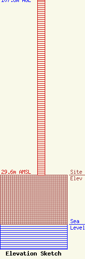
Site Elevation: 29.6 meters (97 ft) |
| Height of Structure: 106.7 meters (350 feet) |
| Overall Height Above Ground: 107.6 meters (353 feet) |
| Overall Height Above Mean Sea Level: 137.2 meters (450 feet) |
| Owner Info | DAIJ Media, LLC
1600 Pasadena Blvd.
Pasadena, TX 77502
(713) 589-1336
ruben75@gmail.com |
| Contact Info | Booth, Feret & Imlay LLC
14356 Cape May Road
Silver Spring, MD 20904-6011
Christopher Imlay
(301) 384-5525
chris@imlaylaw.com |
