|
|
Antenna Structure Registration 1240955 |
 |
Registration Info | Registration Number: 1240955 |
| File Number: A0757133 |
| FAA Study: 2003-ASO-3239-OE |
| FAA Issue Date: 09/09/2003 |
| Status: Constructed |
| Date Constructed: 11/17/2004 |
| FAA EMI: N |
| NEPA: N |
Structure Info
| Structure Type: TOWER |
| Structure Coordinates: 37-52-50.9 N 84-19-15.9 W (NAD 83) |
| Structure Coordinates: 37-52-50.6 N 84-19-16.1 W (Converted to NAD 27) |
| Structure Address: 4282 Simpson Road |
| Structure City: Clays Ferry, KY |
| Structure County: Madison County |
| Painting & Lighting Info |
FAA Circular #: 70/7460-1K |
FAA Chapters: 4, 9, 12 |
Remarks: Removed expiration and final dates from determination. Scenario 2./jjs/case#635066 |
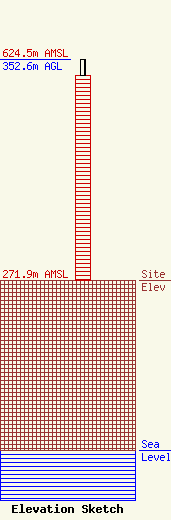
| Elevation Info |
Site Elevation: 271.9 meters (892 ft) |
| Height of Structure: 328 meters (1076 feet) |
| Overall Height Above Ground: 352.6 meters (1157 feet) |
| Overall Height Above Mean Sea Level: 624.5 meters (2049 feet) |
| Owner Info | WDKY, Inc.
10706 Beaver Dam Road
Cockeysville, MD 21030
(410) 568-1500
|
