|
|
Antenna Structure Registration 1241013 |
 |
Registration Info | Registration Number: 1241013 |
| File Number: A0353848 |
| FAA Study: 2003-ASO-5457-OE |
| FAA Issue Date: 10/30/2003 |
| Status: Granted |
| NEPA: N |
Structure Info
| Structure Type: TOWER |
| Structure Coordinates: 35-12-26.2 N 78-3-19.2 W (NAD 83) |
| Structure Coordinates: 35-12-25.6 N 78-03-20.2 W (Converted to NAD 27) |
| Structure Address: 990 North Center Street |
| Structure City: Mount Olive, NC |
| Structure County: Wayne County |
| Painting & Lighting Info |
FAA Circular #: 70/7460-1K |
FAA Chapters: 3, 4, 5, 12 |
| Elevation Info |
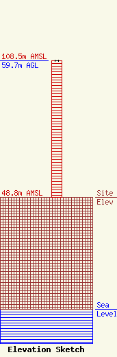
Site Elevation: 48.8 meters (160 ft) |
| Height of Structure: 59.7 meters (196 feet) |
| Overall Height Above Ground: 59.7 meters (196 feet) |
| Overall Height Above Mean Sea Level: 108.5 meters (356 feet) |
| Info |
