|
|
Antenna Structure Registration 1241067 |
 |
Registration Info | Registration Number: 1241067 |
| File Number: A1300809 |
| FAA Study: 2024-AGL-10312-OE |
| FAA Issue Date: 10/02/2024 |
| Status: Constructed |
| Date Constructed: 06/09/2005 |
| NEPA: N |
Structure Info
| Structure Type: LTOWER |
| Structure Coordinates: 40-3-42.0 N 80-45-29.2 W (NAD 83) |
| Structure Coordinates: 40-03-41.7 N 80-45-29.9 W (Converted to NAD 27) |
| Structure Address: 67315 Kirkwood Heights Rd |
| Structure City: Brookside, OH |
| Structure County: Belmont County |
| Painting & Lighting Info |
FAA Circular #: 70/7460-1K |
FAA Chapters: 4, 8, 12 |
Remarks: OM&L to remain the same as prior study = A MED-DUAL SYSTEM |
Remarks: PRIOR STUDY 2003-AGL-6092-OE |
Remarks: OM&L to remain the same as prior study = A MED-DUAL SYSTEM |
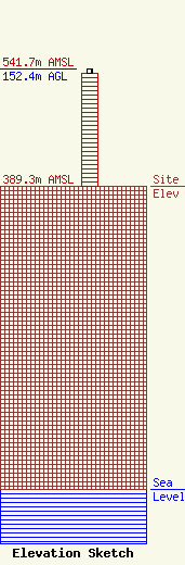
| Elevation Info |
Site Elevation: 389.3 meters (1277 ft) |
| Height of Structure: 146.3 meters (480 feet) |
| Overall Height Above Ground: 152.4 meters (500 feet) |
| Overall Height Above Mean Sea Level: 541.7 meters (1777 feet) |
| Owner Info | OHIO, STATE OF
1320 ARTHUR E. ADAMS DRIVE, RM 401
COLUMBUS, OH 43221
(866) 646-2727
DAS.MARCSNOC@DAS.OHIO.GOV |
| Contact Info | OHIO, STATE OF
4200 SURFACE ROAD
COLUMBUS, OH 43228
DEVAN PHILLIS
(614) 282-3848
DEVAN.PHILLIS@DAS.OHIO.GOV |
