|
|
Antenna Structure Registration 1241542 |
 |
Registration Info | Registration Number: 1241542 |
| File Number: A1070415 |
| FAA Study: 2003-AEA-3416-OE |
| FAA Issue Date: 12/12/2003 |
| Status: Constructed |
| Date Constructed: 07/31/2004 |
| FAA EMI: N |
| NEPA: N |
Structure Info
| Structure Type: TOWER |
| Structure Coordinates: 39-22-49.3 N 81-11-35.4 W (NAD 83) |
| Structure Coordinates: 39-22-49.0 N 81-11-36.0 W (Converted to NAD 27) |
| Structure Address: Greens Run Rd. |
| Structure City: St. Marys, WV |
| Structure County: Pleasants County |
| Painting & Lighting Info |
FAA Circular #: 70/7460-1K |
FAA Chapters: 3, 4, 5, 12 |
Remarks: Removed expiration date from determination. Scenario 1./jjs/case#635066 |
Remarks: PRIOR STUDY 1987-AEA-130-OE |
Remarks: Removed expiration date from determination. Scenario 1./jjs/case#635066 |
Remarks: PRIOR STUDY 1987-AEA-130-OE |
| Elevation Info |
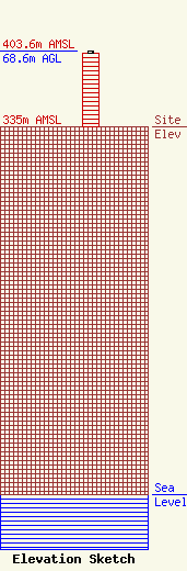
Site Elevation: 335 meters (1099 ft) |
| Height of Structure: 67 meters (220 feet) |
| Overall Height Above Ground: 68.6 meters (225 feet) |
| Overall Height Above Mean Sea Level: 403.6 meters (1324 feet) |
| Owner Info | Seven Ranges Radio Co., Inc.
2354 Greens Run Rd.
374
St. Marys, WV 26170-0374
(304) 684-3400
tpt@LiteRock93R.Com |
| Info |
