|
|
Antenna Structure Registration 1242393 |
 |
Registration Info | Registration Number: 1242393 |
| File Number: A0788310 |
| FAA Study: 2004-ACE-49-OE |
| FAA Issue Date: 01/28/2004 |
| Status: Constructed |
| Date Constructed: 05/26/2006 |
| FAA EMI: N |
| NEPA: N |
Structure Info
| Structure Type: TOWER |
| Structure Coordinates: 41-34-17.0 N 98-55-22.3 W (NAD 83) |
| Structure Coordinates: 41-34-17.0 N 98-55-21.0 W (Converted to NAD 27) |
| Structure Address: South Of City |
| Structure City: Ord, NE |
| Structure County: Valley County |
| Painting & Lighting Info |
FAA Circular #: 70/7460-1K |
FAA Chapters: 4, 6, 12 |
Remarks: Removed expiration and final dates from determination. Scenario 2./jjs/case#635066 |
| Elevation Info |
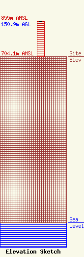
Site Elevation: 704.1 meters (2310 ft) |
| Height of Structure: 150 meters (492 feet) |
| Overall Height Above Ground: 150.9 meters (495 feet) |
| Overall Height Above Mean Sea Level: 855 meters (2805 feet) |
| Owner Info | MJ Leasing LLC
1622 Clearview Blvd
York, NE 68467
Mark Jensen
(402) 362-4361
mwbbroadcasting@hotmail.com |
| Contact Info | MJ Leasing LLC
1622 Clearview Blvd
York, NE 68467
Mark Jensen
(402) 362-4433
mwbbroadcasting@hotmail.com |
