|
|
Antenna Structure Registration 1242893 |
 |
Registration Info | Registration Number: 1242893 |
| File Number: A1135030 |
| FAA Study: 2005-AEA-1640-OE |
| FAA Issue Date: 06/06/2005 |
| Status: Constructed |
| Date Constructed: 09/09/2005 |
| FAA EMI: N |
| NEPA: N |
Structure Info
| Structure Type: TOWER |
| Structure Coordinates: 38-39-11.4 N 80-43-9.4 W (NAD 83) |
| Structure Coordinates: 38-39-11.0 N 80-43-10.0 W (Converted to NAD 27) |
| Structure Address: Twistville Road |
| Structure City: Sutton, WV |
| Structure County: Braxton County |
| Painting & Lighting Info |
FAA Chapters: NONE |
Remarks: PRIOR STUDY 2001-AEA-5083-OE |
| Elevation Info |
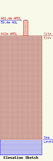
Site Elevation: 402 meters (1319 ft) |
| Height of Structure: 59.4 meters (195 feet) |
| Overall Height Above Ground: 59.4 meters (195 feet) |
| Overall Height Above Mean Sea Level: 461.4 meters (1514 feet) |
| Owner Info | Summit Media Broadcasting, LLC
120 Main Street
Sutton, WV 26601
(304) 765-7373
al@summitmediawv.com |
| Contact Info | Summit Media Broadcasting, LLC
120 Main Street
Sutton, WV 26601
Nunzio Sergi
(304) 765-7373
al@summitmediawv.com |
