|
|
Antenna Structure Registration 1243745 |
 |
Registration Info | Registration Number: 1243745 |
| File Number: A0724224 |
| FAA Study: 2004-ANE-438-OE |
| FAA Issue Date: 05/12/2004 |
| Status: Constructed |
| Date Constructed: 03/10/2003 |
| FAA EMI: N |
| NEPA: N |
Structure Info
| Structure Type: TOWER |
| Structure Coordinates: 44-47-18.0 N 68-49-36.0 W (NAD 83) |
| Structure Coordinates: 44-47-17.7 N 68-49-37.9 W (Converted to NAD 27) |
| Structure Address: 184 Target Circle |
| Structure City: Bangor, ME |
| Structure County: Penobscot County |
| Painting & Lighting Info |
FAA Chapters: NONE |
| Elevation Info |
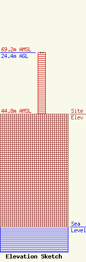
Site Elevation: 44.8 meters (147 ft) |
| Height of Structure: 24.4 meters (80 feet) |
| Overall Height Above Ground: 24.4 meters (80 feet) |
| Overall Height Above Mean Sea Level: 69.2 meters (227 feet) |
| Owner Info | Blueberry Broadcasting, LLC
3059
Kennebunkport, ME 04046
(207) 967-6161
|
| Contact Info | Blueberry Broadcasting, LLC
3059
Kennebunkport, ME 04046
Louis Vitali
(207) 967-6161
|
