|
|
Antenna Structure Registration 1244014 |
 |
Registration Info | Registration Number: 1244014 |
| File Number: A1087818 |
| FAA Study: 2004-AGL-1137-OE |
| FAA Issue Date: 04/14/2004 |
| Status: Constructed |
| Date Constructed: 07/14/2004 |
| FAA EMI: N |
| NEPA: N |
Structure Info
| Structure Type: TOWER |
| Structure Coordinates: 39-59-16.0 N 83-4-4.0 W (NAD 83) |
| Structure Coordinates: 39-59-15.8 N 83-04-04.3 W (Converted to NAD 27) |
| Structure Address: W. 5th Avenue & Lakeshore Drive |
| Structure City: Columbus, OH |
| Structure County: Franklin County |
| Painting & Lighting Info |
FAA Chapters: NONE |
| Elevation Info |
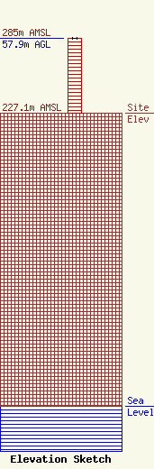
Site Elevation: 227.1 meters (745 ft) |
| Height of Structure: 57.9 meters (190 feet) |
| Overall Height Above Ground: 57.9 meters (190 feet) |
| Overall Height Above Mean Sea Level: 285 meters (935 feet) |
| Owner Info | Citicasters Co.
7136 S. Yale Avenue
TULSA, OK 74136
(918) 664-4581
fcccontact@iheartmedia.com |
| Contact Info | iHeartMedia, Inc.
7136 S. Yale Avenue
TULSA, OK 74136
(918) 664-4581
fcccontact@iheartmedia.com |
