|
|
Antenna Structure Registration 1244488 |
 |
Registration Info | Registration Number: 1244488 |
| File Number: A1047094 |
| FAA Study: 97-ASO-0387-OE |
| FAA Issue Date: 02/14/1997 |
| Status: Constructed |
| Date Constructed: 04/01/1997 |
| FAA EMI: N |
| NEPA: N |
Structure Info
| Structure Type: BTWR |
| Structure Coordinates: 34-0-4.4 N 81-2-4.8 W (NAD 83) |
| Structure Coordinates: 34-00-03.8 N 81-02-05.5 W (Converted to NAD 27) |
| Structure Address: Us 1 Between Assembly Street (us 48) And Main Street |
| Structure City: Columbia, SC |
| Structure County: Richland County |
| Painting & Lighting Info |
FAA Circular #: 70/7460-1J |
FAA Chapters: 3, 4, 5, 13 |
Remarks: Removed expiration date from determination. Scenario 1./jjs/case#635066 |
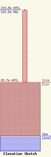
| Elevation Info |
Site Elevation: 88.7 meters (291 ft) |
| Height of Structure: 119.2 meters (391 feet) |
| Overall Height Above Ground: 120.1 meters (394 feet) |
| Overall Height Above Mean Sea Level: 208.8 meters (685 feet) |
| Owner Info | Midlands Media Group LLC
1010 Gervais Street
Columbia, SC 29201
(301) 908-3412
Kirk@MidlandsMediaGroup.com |
| Contact Info | Lerman Senter PLLC
2001 L Street, NW
Washington, DC 20036
Erin Kim
(202) 429-8970
ekim@lermansenter.com |
