|
|
Antenna Structure Registration 1245781 |
 |
Registration Info | Registration Number: 1245781 |
| File Number: A1121369 |
| FAA Study: 2010-AEA-2357-OE |
| FAA Issue Date: 07/21/2010 |
| Status: Constructed |
| Date Constructed: 11/01/2004 |
| NEPA: N |
Structure Info
| Structure Type: BMAST |
| Structure Coordinates: 40-45-42.4 N 73-58-6.3 W (NAD 83) |
| Structure Coordinates: 40-45-42.0 N 73-58-07.8 W (Converted to NAD 27) |
| Structure Address: 731 Lexington Avenue |
| Structure City: New York, NY |
| Structure County: New York County |
| Painting & Lighting Info |
FAA Circular #: 70/7460-1K |
FAA Chapters: 4, 8, 12 |
Remarks: PRIOR STUDY 2007-AEA-1672-OE |
| Elevation Info |
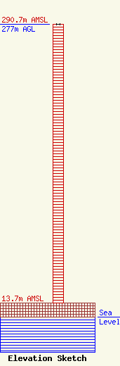
Site Elevation: 13.7 meters (45 ft) |
| Height of Structure: 277 meters (909 feet) |
| Overall Height Above Ground: 277 meters (909 feet) |
| Overall Height Above Mean Sea Level: 290.7 meters (954 feet) |
| Owner Info | 731 Commercial LLC c/o Vornado Realty Trust
888 Seventh Avenue - 44th Floor
New York, NY 10019
(212) 894-7000
tdunlap@vno.com |
| Contact Info | 731 Commercial LLC c/o Vornado Realty Trust
888 Seventh Avenue - 44th Floor
New York, NY 10019
(212) 888-4360
blok@vno.com |
