|
|
Antenna Structure Registration 1246136 |
 |
Registration Info | Registration Number: 1246136 |
| File Number: A1150243 |
| FAA Study: 2004-ASO-5929-OE |
| FAA Issue Date: 11/16/2004 |
| Status: Constructed |
| Date Constructed: 02/01/1995 |
| FAA EMI: Y |
| NEPA: N |
Structure Info
| Structure Type: TOWER |
| Structure Coordinates: 33-57-49.8 N 81-4-42.5 W (NAD 83) |
| Structure Coordinates: 33-57-49.2 N 81-04-43.2 W (Converted to NAD 27) |
| Structure Address: 1801 Charleston Highway |
| Structure City: Cayce, SC |
| Structure County: Lexington County |
| Painting & Lighting Info |
FAA Chapters: NONE |
Remarks: PRIOR STUDY 1996-ASO-1321-OE |
| Elevation Info |
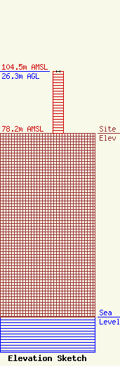
Site Elevation: 78.2 meters (257 ft) |
| Height of Structure: 26.2 meters (86 feet) |
| Overall Height Above Ground: 26.3 meters (86 feet) |
| Overall Height Above Mean Sea Level: 104.5 meters (343 feet) |
| Owner Info | Cumulus Radio, LLC
3280 Peachtree Rd, Suite 2200
Atlanta, GA 30305
(404) 949-0700
towermanagement@cumulus.com |
| Contact Info | Cumulus Radio, LLC
2300 Vartan Way, Suite 130
Harrisburg, PA 17110
David Supplee
(717) 901-0720
dave.supplee@cumulus.com |
