|
|
Antenna Structure Registration 1246793 |
 |
Registration Info | Registration Number: 1246793 |
| File Number: A1150242 |
| FAA Study: 2004-AGL-6578-OE |
| FAA Issue Date: 01/07/2005 |
| Status: Constructed |
| Date Constructed: 01/14/2005 |
| FAA EMI: N |
| NEPA: N |
Structure Info
| Structure Type: TOWER |
| Structure Coordinates: 43-11-27.4 N 86-14-15.6 W (NAD 83) |
| Structure Coordinates: 43-11-27.3 N 86-14-15.4 W (Converted to NAD 27) |
| Structure Address: 3375 Merrium Street |
| Structure City: Muskegon, MI |
| Structure County: Muskegon County |
| Painting & Lighting Info |
FAA Chapters: NONE |
Remarks: Removed expiration date from determination. Scenario 1./jjs/case#635066 |
| Elevation Info |
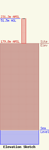
Site Elevation: 179.8 meters (590 ft) |
| Height of Structure: 51.5 meters (169 feet) |
| Overall Height Above Ground: 51.5 meters (169 feet) |
| Overall Height Above Mean Sea Level: 231.3 meters (759 feet) |
| Owner Info | Cumulus Radio, LLC
3280 Peachtree Rd, Suite 2200
Atlanta, GA 30305
(404) 949-0700
towermanagement@cumulus.com |
| Contact Info | Cumulus Radio, LLC
2300 Vartan Way, Suite 130
Harrisburg, PA 17110
David Supplee
(717) 901-0720
dave.supplee@cumulus.com |
