|
|
Antenna Structure Registration 1247411 |
 |
Registration Info | Registration Number: 1247411 |
| File Number: A0430833 |
| FAA Study: 2005-ASW-416-OE |
| FAA Issue Date: 03/02/2005 |
| Status: Granted |
| NEPA: N |
Structure Info
| Structure Type: BTWR |
| Structure Coordinates: 34-10-28.0 N 97-8-3.0 W (NAD 83) |
| Structure Coordinates: 34-10-27.7 N 97-08-01.9 W (Converted to NAD 27) |
| Structure Address: 115 W. Broadway |
| Structure City: Ardmore, OK |
| Structure County: Carter County |
| Painting & Lighting Info |
FAA Circular #: 70/7460-1K |
FAA Chapters: 3, 4, 5, 12 |
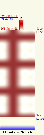
| Elevation Info |
Site Elevation: 266.7 meters (875 ft) |
| Height of Structure: 30.5 meters (100 feet) |
| Overall Height Above Ground: 39.6 meters (130 feet) |
| Overall Height Above Mean Sea Level: 306.3 meters (1005 feet) |
| Owner Info | On The Air, Inc.
115 W. Broadway, Ste. 501
Ardmore, OK 73401
(580) 226-9797
|
| Contact Info | Broadcast Works
2122 Anthony Drive
Tyler, TX 75701
Hank Hardisty
(903) 509-2470
hank@broadcastworks.com |
