|
|
Antenna Structure Registration 1248005 |
 |
Registration Info | Registration Number: 1248005 |
| File Number: A0447778 |
| FAA Study: 2003-AEA-2086-OE |
| FAA Issue Date: 02/01/2005 |
| Status: Constructed |
| Date Constructed: 05/12/2005 |
| FAA EMI: N |
| NEPA: N |
Structure Info
| Structure Type: BTWR |
| Structure Coordinates: 39-58-50.4 N 75-9-24.6 W (NAD 83) |
| Structure Coordinates: 39-58-50.0 N 75-09-26.0 W (Converted to NAD 27) |
| Structure Address: 1805 N. Broad Street |
| Structure City: Philadelphia, PA |
| Structure County: Philadelphia County |
| Painting & Lighting Info |
FAA Circular #: 70/7460-1K |
FAA Chapters: 4, 5, 12 |
Remarks: Removed expiration date from determination. Scenario 1./jjs/case#635066 |
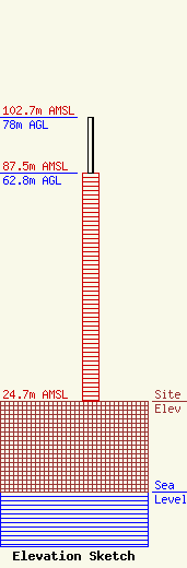
| Elevation Info |
Site Elevation: 24.7 meters (81 ft) |
| Height of Structure: 62.8 meters (206 feet) |
| Overall Height Above Ground: 78 meters (256 feet) |
| Overall Height Above Mean Sea Level: 102.7 meters (337 feet) |
| Owner Info | Temple University of the Commonwealth System of Higher Education
1509 Cecil B. Moore Avenue
Philadelphia, PA 19121-3410
(215) 204-8405
jeff@wrti.org |
| Contact Info | Irwin, Campbell & Tannenwald, P.C.
1730 Rhode Island Ave NW Ste 200
Washington, DC 20036-3120
Peter Tannenwald
(202) 728-0400
ptannenwald@ictpc.com |
