|
|
Antenna Structure Registration 1248244 |
 |
Registration Info | Registration Number: 1248244 |
| File Number: A1134020 |
| FAA Study: 2017-ASW-7973-OE |
| FAA Issue Date: 08/02/2017 |
| Status: Constructed |
| Date Constructed: 12/08/2006 |
| NEPA: N |
Structure Info
| Structure Type: GTOWER |
| Structure Coordinates: 33-30-8.3 N 101-52-21.3 W (NAD 83) |
| Structure Coordinates: 33-30-08.0 N 101-52-19.7 W (Converted to NAD 27) |
| Structure Address: 100th & University |
| Structure City: Lubbock, TX |
| Structure County: Lubbock County |
| Painting & Lighting Info |
FAA Circular #: 70/7460-1K |
FAA Chapters: 4, 9, 12 |
Remarks: PRIOR STUDY 2007-ASW-3651-OE |
Remarks: OM&L to remain the same as prior study = A HIGH-DUAL SYSTEM |
Remarks: PRIOR STUDY 2007-ASW-3651-OE |
Remarks: OM&L to remain the same as prior study = A HIGH-DUAL SYSTEM |
| Elevation Info |
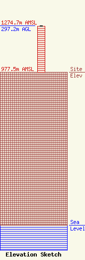
Site Elevation: 977.5 meters (3207 ft) |
| Height of Structure: 295.7 meters (970 feet) |
| Overall Height Above Ground: 297.2 meters (975 feet) |
| Overall Height Above Mean Sea Level: 1274.7 meters (4182 feet) |
| Owner Info | FLP Ramar, Ltd.
3757
Lubbock, TX 79452
(806) 745-9300
bmoran@ramarcom.com |
| Contact Info | Telecommunications Law Professionals PLCC
1025 Connecticut Ave, NW
Washington, DC 20036
Dennis Corbett
(202) 789-3115
dcorbett@telecomlawpros.com |
