|
|
Antenna Structure Registration 1248516 |
 |
Registration Info | Registration Number: 1248516 |
| File Number: A0516174 |
| FAA Study: 90-AEA-1896-OE |
| FAA Issue Date: 08/05/1991 |
| Status: Constructed |
| Date Constructed: 06/29/2005 |
| FAA EMI: N |
| NEPA: N |
Structure Info
| Structure Type: TOWER |
| Structure Coordinates: 37-15-2.0 N 80-5-0.0 W (NAD 83) |
| Structure Coordinates: 37-15-01.5 N 80-05-00.9 W (Converted to NAD 27) |
| Structure Address: Off 12 O'clock Knob Road |
| Structure City: Salem, VA |
| Structure County: Roanoke County |
| Painting & Lighting Info |
FAA Chapters: NONE |
| Elevation Info |
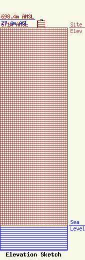
Site Elevation: 671 meters (2201 ft) |
| Height of Structure: 24.3 meters (80 feet) |
| Overall Height Above Ground: 27.4 meters (90 feet) |
| Overall Height Above Mean Sea Level: 698.4 meters (2291 feet) |
| Owner Info | Roanoke County of
1216 Kessler Mill Road
Salem, VA 24153
(540) 387-6223
rthompson@roanokecountyva.gov |
| Contact Info | Roanoke County Communications Shop
1216 Kessler Mill Road
Salem, VA 24153
Rodney Thompson
(540) 387-6223
rthompson@roanokecountyva.gov |
