|
|
Antenna Structure Registration 1249892 |
 |
Registration Info | Registration Number: 1249892 |
| File Number: A1221721 |
| FAA Study: 2005-AGL-3881-OE |
| FAA Issue Date: 08/25/2005 |
| Status: Constructed |
| Date Constructed: 08/31/1989 |
| FAA EMI: N |
| NEPA: N |
Structure Info
| Structure Type: TOWER |
| Structure Coordinates: 38-38-47.2 N 87-16-47.1 W (NAD 83) |
| Structure Coordinates: 38-38-47.0 N 87-16-47.0 W (Converted to NAD 27) |
| Structure Address: 300 Feet Southeast Of Us 50 And 150; 1.4 Miles Southeast Of Wheatland |
| Structure City: Wheatland, IN |
| Structure County: Knox County |
| Painting & Lighting Info |
FCC Paragraph(s): 1, 3, 12, 21 |
Remarks: Continue As Is OM&L = PAINT/RED LIGHTS |
Remarks: PRIOR STUDY 1988-AGL-1410-OE |
Remarks: Continue As Is OM&L = PAINT/RED LIGHTS |
Remarks: PRIOR STUDY 1988-AGL-1410-OE |
| Elevation Info |
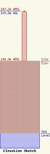
Site Elevation: 146.3 meters (480 ft) |
| Height of Structure: 99.9 meters (328 feet) |
| Overall Height Above Ground: 100.9 meters (331 feet) |
| Overall Height Above Mean Sea Level: 247.2 meters (811 feet) |
| Owner Info | Shake Broadcasting, LLC
800 West National Highway
47501
Washington, IN 47501
(812) 254-6761
fcclaw@rjhayes.com |
| Contact Info | Shake Broadcasting, LLC
800 West National Highway
47501
Washington, IN 47501
DeWayne Shake
(812) 254-6761
fcclaw@rjhayes.com |
