|
|
Antenna Structure Registration 1250006 |
 |
Registration Info | Registration Number: 1250006 |
| File Number: A1192798 |
| FAA Study: 2005-AGL-3538-OE |
| FAA Issue Date: 08/29/2005 |
| Status: Constructed |
| Date Constructed: 07/01/1991 |
| FAA EMI: N |
| NEPA: N |
Structure Info
|
| Structure Coordinates: 42-13-30.1 N 89-2-53.7 W (NAD 83) |
| Structure Coordinates: 42-13-30.0 N 89-02-53.3 W (Converted to NAD 27) |
| Structure Address: Sandy Hollow Road |
| Structure City: Rockford, IL |
| Structure County: Winnebago County |
| Painting & Lighting Info |
FAA Chapters: NONE |
| Elevation Info |
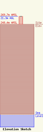
Site Elevation: 248.4 meters (815 ft) |
| Height of Structure: 21.3 meters (70 feet) |
| Overall Height Above Ground: 21.3 meters (70 feet) |
| Overall Height Above Mean Sea Level: 269.7 meters (885 feet) |
| Owner Info | Long Nine, Inc.
460
Springfield, IL 62705
(217) 629-7077
mpaterson@rmgmwf.com |
| Contact Info | Long Nine, Inc.
460
Springfield, IL 62705
(217) 629-7077
mpaterson@rmgmwf.com |
